
Close

Shop All:Nystrom
Nystrom U.S. and World Map Early Learning Classroom Pack with Globe

Item #:
1398255
Sign In
To See Your Price
Ships Directly from Manufacturer Typically Within 2-4 Weeks - Lead Times Vary
Free Shipping Eligible: Details
School Specialty Shipping Policy
Items Shipped Within the Contiguous 48 United States
Ships Free
- Item Ships Free with your pricing program.
Free Shipping Eligible
- Free shipping and handling on eligible supply orders of $69 or more. Free shipping calculation is based on the subtotals of eligible items, after any additional discounts are applied.
- For subtotals less than $69, the shipping and handling charge is $11.95.
Free Shipping Eligible with your Pricing Program
- If the pricing program minimum subtotal is met item Ships Free with your Pricing Program. Free shipping calculation is based on the subtotals of eligible items on your pricing program, after any additional discounts are applied.
- Free Shipping Eligible when Pricing Program minimum is met. If the pricing program minimum subtotal is not met shipping and handling charges are 20% of the subtotal of the items, after any additional discounts are applied, with a $99 minimum charge.
Free Shipping Ineligible
- Shipping and handling charges are 20% of the subtotal of the items, after any discounts are applied, with a $11.95 minimum charge.
Free Shipping Ineligible
- Shipping and handling charges are 20% of the subtotal of the items, after any discounts are applied, with a $99 minimum charge. If the subtotal is greater than $1,000, please call 1-877-350-0645 or E-mail freight_quote@schoolspecialty.com for a freight quote
*Note: Individually negotiated shipping policies will override the standard shipping policy. See Full Details
Items Shipped to Hawaii, Alaska and International
See our Hawaii & Alaska Shipping Policy and International Shipping Policy for details.
About This Item
Description
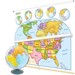
Nystrom Early Learning United States and World Map Combo Classroom Pack comes with a United States map, world map, and 16th inch raised-relief globe (all markable). The world map and the globe emphasize continents by making each one a different color; country boundaries are shown as red lines, with each country labeled by name. To keep the presentation simple, longitude and latitude are omitted (except the Equator) are shown. The U.S. map emphasizes states by color, with each state labeled; capitals and a few of the most major cities are shown. U.S. insets include a locator map, Alaska, and Hawaii; five world-map insets rotate globe views to put different continents front and center. Both maps have shaded relief and legends that explicitly explain how map symbols and conventions work. The maps measure 65 W x 54 H and come mounted on one heavy-duty metal spring-roller with a backboard designed for hanging from a map rack or a one-inch map rail (not included). Grades K to 1.Features
Shipping Type:
parcel
Free Shipping:
true
Specifications
Certifications:
Not Applicable
Maximum Grade Level:
Grade 1
Allergens:
Contains No Allergens
 No Choking Hazard